What You Can Do with Your Land in Selwyn & Waimakariri
The Quick Answer
To check what you can build or subdivide on your property in Selwyn or Waimakariri:
1. Use the ePlan (GIS map) to find your property
2. Identify your zoning
3. Check for overlays or special areas
4. Review development rules (height, setbacks, density)
5. Confirm if your project is permitted or needs resource consent
This article is part of our “How to Use the District Plan Without Getting Lost” series.
Across New Zealand, District Plans set the rules for what can be built, where, and under what conditions. While the purpose is similar everywhere, each council presents its District Plan information slightly differently.
In this series, we break down how to find and use key planning information for different councils, focusing on where to start and what matters most when you are checking development potential for a property.
You can also read our other guides in this series:
- Auckland Council – click here
- Christchurch City Council – click here
- West Coast (South Island) – click here
Understanding the Selwyn & Waimakariri District Plans
This article focuses specifically on the Selwyn and Waimakariri District Plans, which are presented in very similar ways and can be navigated using the same general approach.
Selwyn District Council and Waimakariri District Council use the same type of online system to present their District Plan maps and planning rules.
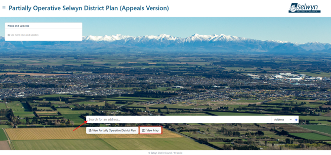
Start With ePlan
The best place to begin is the council’s ePlan, an online GIS-based District Plan viewer.
You can:
- Search your property by address
- View zoning and overlays
- Access relevant planning rules
- Selwyn District Council ePlan
- Waimakariri District Council ePlan
Tip: You can start by either typing the property address directly into the search bar, or by clicking “View Map” and searching from there.

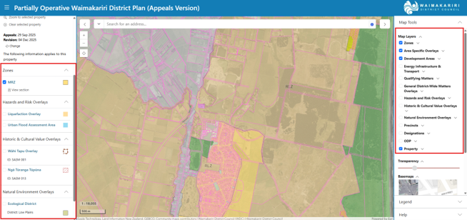
Once the property is located, a summary panel will appear on the left-hand side of the screen. This panel shows the zone, any overlays, and other planning notes that apply to the site.
Tip: To better understand how the rules interact with the land, turn on ALL the available map information. Seeing this information mapped across the site makes it easier to understand whether planning constraints apply to the entire property or only part of it.
Check The Zone (Key to Development Potential)
Zoning is the most important factor when assessing what you can do with your land.
Common zones in Selwyn & Waimakariri:
- Residential zones (e.g. Large Lot, Medium Density)
- Rural zones
- Industrial zones
- Business zones (local centres, town centres)
What zoning controls:
- What activities are allowed
- Subdivision potential
- Density and building scale
- Development expectations
For example:
A Large Lot Residential zone may limit subdivision potential compared to a Medium Density zone, even if the sites are similar in size.
Each zone comes with its own set of rules, controlling building height, setbacks from boundaries, site coverage, and subdivision potential.
Look for Overlays and Special Areas
After zoning, check whether your property is affected by overlays or additional planning layers.
Overlays can introduce extra requirements in addition to the zoning rules.
Common overlays in Selwyn and Waimakariri include:
- Flood hazard areas
- Heritage listings
- Notable trees
- Landscape or coastal protection areas
Why this Matters
A property can sit within a standard rural or residential zone but still have extra rules because of an overlay. Two neighbouring properties can sometimes have very different development outcomes.
Open the District Plan Rules
Once you know the zone and any overlays, the next step is to open the District Plan itself and look at the relevant rules.
Both Selwyn and Waimakariri District Plans are structured in a similar way, with chapters covering:
- Zoning rules and development standards
- Subdivision rules
- Natural hazards
- Transport and access requirements
- Earthworks rules
From ePlan, you can navigate directly to the relevant parts of the District Plan.

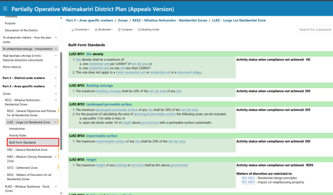
Key Rules to Check (Built Form & Subdivision)
Most property owners and developers should focus on:
- Maximum building height
- Boundary setbacks
- Site coverage limits
- Minimum lot sizes for subdivision
These rules determine whether your project is:
- Permitted (no consent required)
- Restricted or discretionary (consent required)
A Note on Partially Operative District Plans
For both Selwyn District Council and Waimakariri District Council, it is important to note that Partially Operative District Plans are currently in place. This means that while most rules are operative, some provisions are still subject to appeals.
In certain cases, you may need to refer back to the previous version of the District Plan, known as the Operative District Plan, to confirm which rules apply.
Can You Subdivide in Selwyn or Waimakariri?
This is one of the most common questions - and the answer depends on several factors.
Subdivision potential is influenced by:
- Zoning (e.g. rural vs residential)
- Minimum lot size rules
- Infrastructure availability (services, access)
- Overlays (e.g. flood hazards)
In many cases subdivision is possible but resource consent is required.
If you are unsure which version of the rules applies to your property or proposal, seeking planning advice can help avoid confusion, delays, or unnecessary risk.
Why District Plans Can Be Confusing
Even experienced professionals take time to interpret District Plans.
That’s because:
- Rules interact with each other
- Multiple chapters may apply
- Small details can change outcomes
Online maps are a great starting point, but understanding how the rules apply to a specific site often requires looking at the District Plan as a whole.
When to Speak With a Planner
You should consider professional advice if you are:
- Looking to subdivide land
- Buying a development site
- Unsure about zoning or overlays
- Wanting certainty before committing
Early advice can reduce risk, save time and avoid costly design changes.
If you are exploring what you might be able to do on your property and would like planning advice, feel free to get in touch with our team. We’re always happy to have an initial conversation and help you understand the planning framework that applies to your site.
At Inovo, our multidisciplinary team includes planners, surveyors, engineers, and project managers who can support projects from early feasibility through to design, consenting and delivery.
Was this article helpful? Here’s some other topics that might be of interest to you:
National Policy Statement for Natural Hazards (2025): What developers and landowners need to know
What’s the difference between as resource consent and a building consent?
Disclaimer
This article contains general information and opinion based on our expertise. It is provided free of charge and does not constitute legal or other professional advice. The information within it was up to date at the time of publishing.
Have you got further questions about this topic or our other services?
We are always happy to help – drop us an email rmplanning@inovo.nz, or phone us on 020 4000 0294.
.png)