How to Use the Te Tai o Poutini Plan (West Coast District Plan)
To check what you can build or subdivide on the West Coast (Buller, Grey, or Westland):
1. Use the Te Tai o Poutini Plan ePlan (GIS map)
2. Identify your zoning
3. Check for overlays (e.g. coastal hazards, heritage)
4. Review development rules (height, setbacks, density)
5. Confirm if your project is permitted or needs resource consent
This article is part of our “How to Use the District Plan Without Getting Lost” article series.
Across New Zealand, District Plans set the rules for what can be built, where, and under what conditions. While the purpose is similar everywhere, each council presents its District Plan information slightly differently.
In this series, we break down how to find and use key planning information for different councils, focusing on where to start and what matters most when you are checking development potential for a property.
You can also read our other guides in this series:
- Auckland Council – click here
- Christchurch City Council – click here
- Selwyn and Waimakariri District Councils – click here
What Is Te Tai o Poutini Plan?
If you’re planning to build or develop land on the West Coast of New Zealand, the rules are set by a single combined District Plan: Te Tai o Poutini Plan (TTPP)
Unlike most regions, where each council has its own District Plan, the West Coast is moving towards using a single unified plan covering the three main districts that make up the West Coast of the South Island. This includes the Buller District (Westport and Reefton), Grey District (Greymouth), and Westland District (Hokitika, and Southern West Coast).
This means the structure, zoning, and rules are consistent across the region.
Why This Matters for Property Owners and Developers
The Te Tai o Poutini Plan determines:
- What you can build on your land
- Whether you can subdivide
- What constraints apply (e.g. hazards, heritage)
- When resource consent is required
Whether you’re building a house, developing land, or doing due diligence, this is the key document.
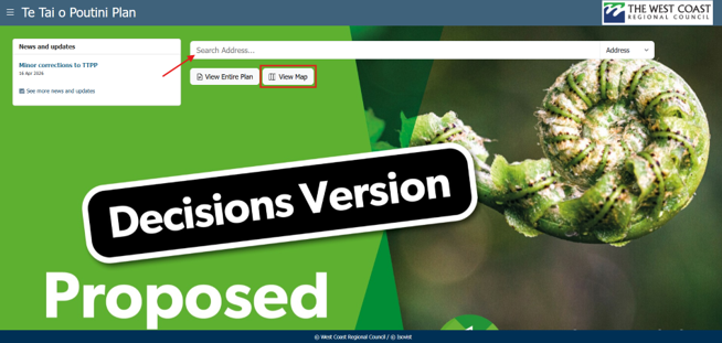
Start With ePlan
The easiest place to begin is the Te Tai o Poutini Plan ePlan.
This is an online GIS-based map that combines:
- Property search
- Zoning information
- Overlays and constraints
- Direct links to planning rules
Using ePlan, you can:
- Search your property address
- View zoning and overlays
- Access relevant plan provisions
In ePlan, you can either search by property address or View Map and search from there.
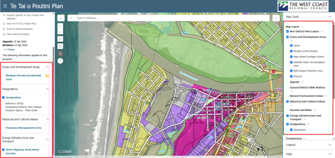
Tip: To better understand how the rules interact with the land, turn on ALL the available map information. Seeing this information mapped across the site makes it easier to understand whether planning constraints apply to the entire property or only part of it.
Tick ALL the options in the right-hand panel. You will see other relevant information applying to the site and vicinity, such as road classification.
Check Your Zoning
Zoning is the foundation of what you can do with your land.
Common zones on the West Coast include:
- General Residential
- Medium Density Residential
- General Rural
- Rural Lifestyle
- Mixed Use
- General Industrial
What zoning controls:
- Permitted activities
- Building height and density
- Subdivision potential
- Overall development expectations
Example:
A property in a Rural Lifestyle zone may allow limited subdivision, while a General Residential zone may enable more intensive development.
Once you know your zone, you can start to understand what the council expects in that area. It also gives you a clearer sense of what you may be able to do on your property and which rules are likely to apply.
Look for Overlays and Special Areas
After zoning, check for overlays, which can significantly affect development.
Common overlays in the Te Tai o Poutini Plan:
- Coastal environment areas
- Flood or coastal inundation hazards
- State highway noise overlays
- Heritage areas
- Pounamu management areas
Why overlays matter:
They can:
- Restrict where or how you build
- Add additional design requirements
- Trigger resource consent
Two properties with the same zoning can have very different outcomes because of overlays.
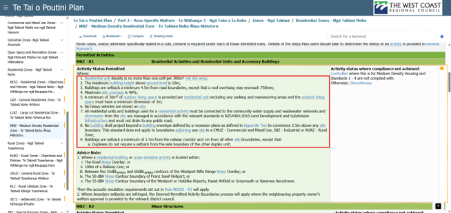
Review the District Plan Rules
Once you know the zone and any overlays, the next step is to open the Te Tai o Poutini Plan rules.
The Plan is organised into chapters covering:
- Zoning and development standards
- Subdivision rules
- Natural hazards
- Transport and access
- Earthworks
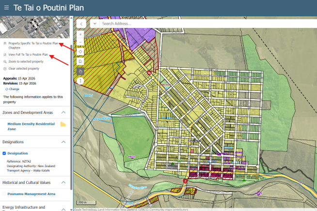
From ePlan, you can pen property-specific chapters, or view the full District Plan.
Key Rules to Check
Most property owners should focus on:
- Maximum building height
- Boundary setbacks
- Site coverage limits
- Subdivision requirements (minimum lot sizes)
These rules determine whether your project is: permitted (no resource consent required), or requires consent (restricted, discretionary, or non-complying).
A Note on Te Tai o Poutini Plan and Operative District Plans
Te Tai o Poutini Plan is relatively new. While the Plan has been through council decisions:
- Some provisions are still under appeal
- Not all rules are fully operative
This means that in some situations, you may also need to refer back to:
Why the Plan Can Still Be Confusing
Even though Te Tai o Poutini Plan is more streamlined than older plans, it can still be complex because:
- Many rules interact with each other
- Multiple rules can apply to one site
- Small details can affect outcomes
Online maps are a great starting point, but understanding how the rules apply to a specific site often requires looking at the District Plan as a whole.
When to Get Planning Advice
You should consider speaking with a planner if you are:
- Looking to subdivide land
- Assessing development feasibility
- Unsure about hazards or overlays
- Wanting certainty before purchasing property
Early advice can reduce risk, save time and cost and improve development outcomes.
Feel free to get in touch with our team. We’re always happy to have an initial conversation and help you understand the planning framework that applies to your site.
At Inovo, our multidisciplinary team includes planners, surveyors, engineers, and project managers who can support projects from early feasibility through to design, consenting and delivery.
Was this article helpful? Here’s some other topics that might be of interest to you:
National Policy Statement for Natural Hazards (2025): What developers and landowners need to know
What’s the difference between as resource consent and a building consent?
Disclaimer
This article contains general information and opinion based on our expertise. It is provided free of charge and does not constitute legal or other professional advice. The information within it was up to date at the time of publishing.
Have you got further questions about this topic or our other services?
We are always happy to help – drop us an email rmplanning@inovo.nz, or phone us on 020 4000 0294.
.png)